Trip Grade
Moderate
Duration
17 Days
Daily Activity
4-6 hours
Country
Nepal
Season
Spring/autonm
Group Size
2-10 Pax
Max Altitude
5,416 meters
Transportation
Private vehicle
ACCOMMODATION
Tea Houses
Trip Type
Trekking
Nepal's Classic Himalayan Journey · 145–190 km · 5,416m Summit Pass
Lush Subtropics → Alpine Wilderness → Tibetan Plateau → Sacred Muktinath → Annapurna Panoramas
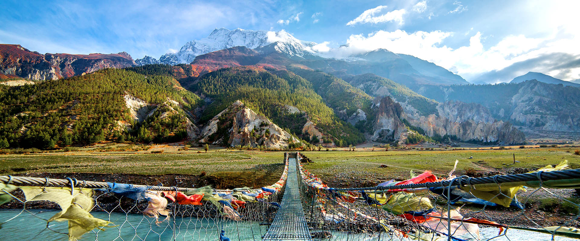
The Annapurna Circuit is widely regarded as one of the world's greatest long-distance treks — a sweeping circular route that winds around the entire Annapurna Massif in north-central Nepal. Spanning 145 to 190 kilometres depending on the route chosen, it delivers an unrivalled cross-section of Himalayan geography, culture and adventure in a single journey.
The trek follows the Marsyangdi River Valley northward, crossing the mighty Thorong La Pass at 5,416 metres before descending into the dramatic, wind-carved landscapes of the upper Kali Gandaki Valley — one of the deepest gorges on Earth. The route then curves south through sacred Muktinath and the high-desert villages of Mustang, eventually softening into terraced farmland, rhododendron forests and the iconic viewpoint of Poon Hill.
For sheer diversity — of scenery, altitude, climate, religion and ethnicity — the Annapurna Circuit has long been considered the benchmark of Himalayan trekking. Subtropical rice paddies give way to alpine meadows and finally to a stark, Tibetan-style moonscape, all within a fortnight's walk. Four peaks exceeding 8,000 metres — Annapurna I (10th highest), Annapurna II, Dhaulagiri I (7th highest) and Manaslu — stand guard along the route.
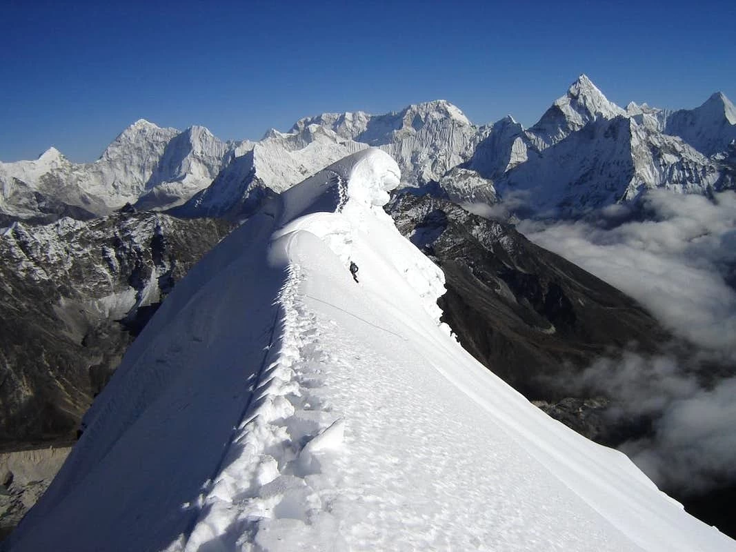
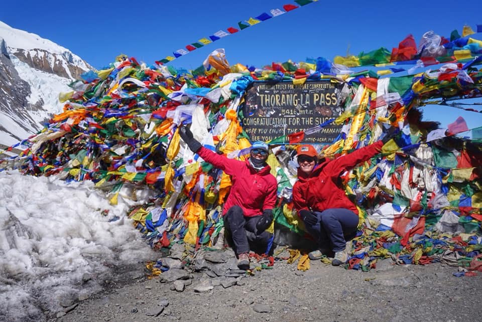
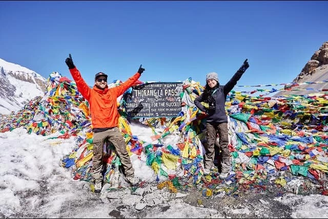
Crossing Thorong La (5,416m / 17,769 ft) is the centrepiece of the entire trek. The ascent begins in darkness — typically 3–4 am — to avoid the fierce afternoon winds that can make the pass impassable. The trail climbs steeply over rock, scree and snow, rewarding those who persevere with panoramic views across the Annapurna and Dhaulagiri ranges that stretch endlessly in every direction. The descent into the Mustang valley is equally dramatic, dropping over 1,600 metres in a single day into a completely different world.
Few treks in the world offer such a complete transition through living cultures. The lower valleys are home to Gurung and Brahmin villages where Hindu shrines and terraced fields dominate. Moving northward, the landscape and people shift — Manang and the villages beyond are inhabited by Manangis and Thakalis, people whose Buddhist heritage, flat-roofed stone houses and trade traditions reflect centuries of connection to Tibet. The contrast is remarkable and deeply enriching.
Perched at 3,760 metres, Muktinath is one of the Himalayan region's most sacred sites. Both Hindus and Buddhists make pilgrimages here to the temple of Vishnu and the flame that burns eternally from natural gas seeps. Descending through the gate of Thorong La to reach this holy town — often in a state of exhausted triumph — is a profoundly moving experience.
Below Jomsom, the route enters the Kali Gandaki Valley, flanked by Dhaulagiri (8,167m) and Annapurna I (8,091m). The gorge between these two giants is considered the world's deepest, with vertical relief exceeding 5,500 metres from the river bed to the summits above. Fossilised ammonites (shaligrams) washed down from ancient ocean floors are sold in the villages along the way — a testament to the extraordinary geology of the Himalaya.
Rather than ending the trek at the dusty airstrip of Jomsom, the classic and highly recommended route continues south-east to Ghorepani (2,860m) and the famous viewpoint of Poon Hill (3,210m). The sunrise from Poon Hill — painting Dhaulagiri, the entire Annapurna range, Hiunchuli and Machhapuchhre (Fishtail) in orange and pink — is one of the most celebrated mountain panoramas in the world.
It would be dishonest not to acknowledge that the Annapurna Circuit has changed significantly over the past two decades. Road construction has reached Chame (2,710m) on the eastern approach and Jomsom (2,720m) on the western side, and vehicles now ply parts of the route that were once remote trails. This has led many trekkers to modify the itinerary.
• Most groups now drive or take a jeep from Besisahar to Ngadi or Bhulbhule (saving one walking day on a motorable road), beginning the trek proper from Ngadi.
• The section between Chame and Manang remains completely on foot and fully unspoiled — spectacular in every sense.
• After Muktinath, the Jomsom–Tatopani road now runs parallel to the old trail; many trekkers choose to walk the quieter paths above the road or take a jeep for part of this section.
• The most rewarding response to the road is to route the trek via Ghorepani and Poon Hill — terrain that no vehicle can reach and that arguably surpasses anything on the circuit itself.
The Annapurna Circuit is classified as Challenging. It requires no technical mountaineering skills — there are no ropes, harnesses or ice axes needed — but the demands of sustained altitude, cumulative distance and the Thorong La crossing mean that good physical fitness and mental resilience are essential prerequisites.
The Annapurna region experiences four distinct seasons, each offering a different experience on the trail.
Post-monsoon skies are brilliantly clear, mountain views are at their best and the landscape has been washed fresh and green. Daytime temperatures are comfortable even at altitude, though nights above 4,000m drop well below freezing. This is the busiest time on the trail — tea houses fill up, so booking ahead is wise. This remains the single best window for the Thorong La crossing.
The pre-monsoon spring season brings warmer temperatures and the extraordinary sight of rhododendrons in full bloom — entire hillsides turn crimson and pink below Ghorepani and Tadapani. Views are slightly hazier than autumn due to pre-monsoon dust, but the colours at lower altitudes are unmatched. Late May sees increasing cloud build-up and occasional pre-monsoon showers.
Winter offers solitude and often crystal-clear views, but Thorong La can be blocked for days or weeks by heavy snowfall and bitter cold. Only experienced trekkers with proper cold-weather gear should attempt a winter crossing. The lower sections of the circuit remain pleasant.
The trail becomes slippery and leeches are active at lower elevations. However, the northern sections above Manang sit in a rain shadow and remain relatively dry. The great benefit is near-total solitude, lush vegetation and dramatic cloud-veiled scenery. Views of the high peaks are intermittent but the landscapes are strikingly beautiful.
The Annapurna Circuit is served by one of the best networks of tea house lodges in the Himalayan world. Standards range from basic to genuinely comfortable, with twin-share rooms, warm common areas, charging facilities and reliable Wi-Fi now standard at most lodges up to Manang. Above 4,000m, facilities become simpler but remain adequate.
Dal Bhat — the traditional Nepali meal of steamed rice, lentil soup, vegetable curry, and pickles — is widely available and almost always served on an unlimited-refill basis. It is perfectly calibrated for trekking: high in complex carbohydrates and deeply satisfying. The Thakali cooks of the Kali Gandaki Valley are particularly renowned for their food, and the apple orchards around Marpha produce the finest apple brandy and apple pie on the circuit.
This itinerary begins with a drive to Ngadi (bypassing the first day on the motorable road), includes a vital acclimatisation day at Manang, crosses Thorong La, and — crucially — continues beyond Jomsom to finish at Ghorepani and Poon Hill, incorporating the Annapurna Panorama and Sunrise Trek for a truly complete experience.
Our Recommendation: If you have the time, always continue to Ghorepani and Poon Hill. Trekkers who end at Jomsom almost universally say — once they see photographs from Poon Hill — that they wish they had continued. The sunrise panorama from Poon Hill is the perfect crescendo to one of the world's great walks.
Trip Highlight
DAY
1
Fly in and transfer to your hotel. Rest, acclimatise to the city altitude, and get your first taste of Kathmandu's streets and food.
DAY
2
Kathmandu sightseeing & trip prep-1,300m / 4,264ft -City day
Explore Thamel, Boudhanath, or Pashupatinath. Collect your ACAP permits and TIMS card. Pack and repack — this is your last chance to shop for gear.
DAY
3
Kathmandu → Dharapani -1,960m / 6,431ft8–9 hrs drive
Long but scenic jeep ride via Tal and Chamje through the Marsyangdi River gorge. Watch the valley walls tighten as you enter the Annapurna Conservation Area.DAY
4
Dharapani → Chame -2,710m / 8,892ft5–6 hrs Trek
Trekking through a string of small Gurung and Tibetan-influenced villages. Forests of pine and rhododendron give way to broader valley views. Chame is the administrative hub of Manang District.
DAY
5
Chame → Upper Pisang -3,700m / 12,140ft5–6 hrs Trek
First dramatic views of Annapurna II and the Paungda Danda rock face. Take the upper trail to Pisang for better mountain panoramas and a more traditional village feel.
DAY
6
Upper Pisang → Manang via Ngawal & Ghyru - 3,519m / 11,546ft4–6 hrsTrek
The high route via Ngawal and Ghyru rewards with sweeping views of Annapurna III, Gangapurna, and Tilicho Peak. A slightly longer but far more rewarding alternative to the valley floor path.
DAY
7
Manang — rest & acclimatisation 3,519m / 11,546ft Acclimatisation
Do not skip this day. Hike to Gangapurna Lake or up to Ice Lake (4,600m) for altitude gains. Attend the Himalayan Rescue Association's free AMS briefing. Sleep low, hike high.
DAY
8
Manang → Yak Kharka -4,110m / 13,485ft3–4 hrsTrek
A shorter day — intentionally so. Grassy pastures at the upper end of the valley with yaks grazing at altitude. Rest well; the landscape becomes noticeably starker above here.
DAY
9
Yak Kharka → Thorong Phedi - 4,420m / 14,502ft3–4 hrsTrek
Short approach to the base of the pass. Many trekkers push up to High Camp (4,925m) for an easier summit day. Sleep early — a 4am start is typical to beat the afternoon winds on the pass.
DAY
10
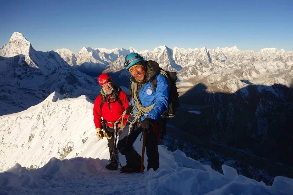
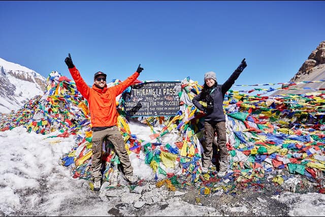
Cross Thorong La → Muktinath Pass: 5,416m / 17,770ft → 3,800m / 12,478ft9–10 hrsTrek
The crux of the circuit. Start at 4 -5 am. The ascent (≈1,000m of elevation gain) is relentless, but the summit cairns and prayer flags are unforgettable. A long descent drops you into Mustang and the sacred temple complex of Muktinath.
DAY
11
DAY
12
Marpha → Tatopani by jeep 1,200m / 3,937ft≈6 hrs drive
Wind-blasted Kali Gandaki gorge — the world's deepest valley — narrows spectacularly. Tatopani means "hot water": soak your legs in the natural hot springs before dinner. Well earned.
DAY
13
Tatopani → Ghorepani 2,850m / 9,351ft 4–6 hrs Trek
A steep climb through dense rhododendron forest — spectacular when in bloom (March–April). Ghorepani is a busy trekking hub; arrive early to find a good teahouse and rest for an early Poon Hill start.
DAY
14
Poon Hill sunrise → Tadapani 2,700m / 8,859ft6–7 hrs totalTrek
Pre-dawn hike to Poon Hill (3,210m) for the most photographed Himalayan panorama in Nepal — Dhaulagiri, Annapurna South, Machhapuchhre, and more lit by sunrise alpenglow. Then trek on to quieter Tadapani.
DAY
15
Tadapani → Pokhara via Ghandruk -Ghandruk 1,940m → Pokhara 827m / 2,713ft5–6 hrs trek + driveTrek + drive
Descend through Ghandruk, the showcase Gurung village with stone-paved lanes and views of Machhapuchhre. Continue down to Kimche or Nayapul and drive to Pokhara. Lakeside awaits.
DAY
16
Pokhara → Kathmandu -1,350m / 4,429 ft, 25 min flight or 6–8 hrs drive Fly/drive
The quick option is a scenic 25-minute mountain flight with Annapurna and Manaslu visible on a clear morning. Those with time can take the Prithvi Highway — a full day's drive through river gorges and hill towns.
DAY
17
Departure- Airport transfer
Transfer to Tribhuvan International Airport. Allow extra time for international check-in. If your flight is in the afternoon, a final spin through Thamel for souvenirs is very doable.
Trip Start: 2025-04-25
Trip End: 2025-05-17
spots available
Trip Start: 2025-10-10
Trip End: 2025-10-26
spots available
The main emphasis while trekking is on keeping warm and dry while still being lightweight. You should bring a rucksack or backpack for the gear required during the day. Your pack should contain items such as warm clothes, a jacket, a camera, water bottles, a personal first aid kit, and snacks. The weight limit is 5kg. A porter will carry the rest of your personal equipment packed in a duffel or kit bag. The weight limit for your duffel bag is 15 kg however it is different in the case of peak climbing and expedition.
A Note on Packing
For your international flights, we recommend that you pack all your equipment in your two duffle bags or suitcase. Do not simply pack your backpack (since the straps can be damaged by the baggage handling machines). It is important to lock these bags for their trip. Depending on the airport, you may be able to put your travel locks on after TSA has searched the bags. If not, Lock the bags with Zip Ties. If the TSA cuts off the zip-tie to search your bag, they will replace it. You will still need the travel locks to lock your bags in the hotel and during the trek. Generally, you will take one duffel on the trek , and leave one in the hotel in Kathmandu with your belongings for your time in the city. Your trek in duffel will only be accessible in the evenings (with items such as changes of clothing, sleeping bag), and your day pack will hold vitals such as water, layering, blister kit, and camera.
FOOTWEAR
Conclusion:
As the weather condition is unpredictable in the Himalayan region, you need to be prepared at all times. A day can start sunny with clear skies and later become cold and windy at the high altitudes.
Sometimes, it can rain and snow during the trekking period. You need to remember that for a successful trekking journey, your physical comfort must be the first priority.
Note:
Please note that these items listed above will vary according to the season, trek duration. Please remember that your luggage will be carried by the porter, but you need to carry a daypack on your own. We also suggest you pack only necessary items to keep the weight of your equipment to a minimum. Carrying a day pack only applies to the trekkers who take the full package with us and those who take only the guide should bring the bag big enough to carry their own stuff. If you have any questions, please do not hesitate to contact us at your convenience.
1
Annapurna Circuit Trekking is a moderately challenging trip around the popular Annapurna region suitable for experienced as well as novice hikers who are passionate about walking, exploring, and adventure with a good level of physical and mental fitness level.
2
For the Annapurna Circuit, October and November or April and May are widely considered to be the best times for trekking. The weather during these two seasons is generally clear and dry, and so it’s not too cold when heading into high altitudes.
3
Annapurna Circuit Trek in December is usually less crowded than any other seasons. The trekking trails are mostly empty and peaceful. The weather condition and temperature of the Annapurna region are bearable during December. The weather might be quite chilly in the higher areas